Center investigators are engaged in resilience modeling and assessment of two small communities. The purpose of these testbeds is multi-fold: to enable the fundamental algorithms in IN-CORE to be initiated, developed and tested at an early stage of the Center research program before the measurement methods, data ontology and databases for modeling physical and social infrastructure systems and networks have fully matured; to provide guidance to NCSA software developers as to the mature of the algorithms that will be incorporated into IN-CORE; and to build working models of collaboration in teams of engineers, social scientists and computer scientists early in the Center research endeavor, something that has been elusive in previous large research centers. These testbeds will test the modeling, linkages and inter-dependencies between simple representations of building inventories, bridges and transportation systems, utility systems and the socioeconomic systems within the community that they support, and will inform the subsequent development of algorithms to estimate impact and recovery trajectories of systems that are essential for community resilience. The current testbeds will inform the development of more refined community resilience assessment methods in subsequent years of the Center research program.
Centerville Community Resilience Testbed
CoE Team: Bruce Ellingwood, John van de Lindt, Harvey Cutler, Sammy Zahran, Naiyu Wang, Charles Nicholson, Paolo Gardoni, Terri McAllister, Erica Kuligowski.
Centerville is a virtual city that was designed to allow the Center investigators maximum flexibility in designing, testing and stressing their algorithms independently prior to the availability of a working version of IN-CORE. Centerville is envisioned as being a typical middle-class city situated in a Midwestern State. Its population is approximately 50,000, and its median household income for its approximately 20,000 households is close to the national average. The Centerville economy is reasonably well diversified, and consists of light manufacturing and industrial facilities, retail, finance and professional services, health care, education, public services, and tourism.
A plan of Centerville is shown in Figure 1 below. A river runs through the center portion of the city, and there is a railway line that follows the east side of the river. While the older section of town adjacent to the river dates back to the early 20th century, most of the current construction dates from the post-WW II era or later. There are seven residential neighborhoods, with a high income/low density (HI/LD) development abutting the western hills, and a mixture of middle income (MI), low income (LI), and middle densities (MD) neighborhoods. There is also a sizeable mobile home park adjacent to one of the industrial facilities. Centerville has two main commercial/retail districts. Local government facilities are in the old center of town, near the river. There are two relatively large industrial facilities, the first being a manufacturing plant for a national marketer of light-frame steel storage buildings commonly used for industrial and agricultural storage, airports and other repair facilities and the second being a storage and trans-shipment facility for an international shipping concern, and several other smaller industrial facilities, many of which are located along the river or the railroad. The hospital is a relatively large facility, which serves Centerville and the surrounding county. There are four public elementary schools, two middle schools and one community high school. Only limited public transportation is available, and most residents depend on private automobiles for transportation.
Centerville is located approximately 200 miles from the New Madrid Seismic Zone, and thus is susceptible to low-probability moderate to major seismic hazards. It is also close to "tornado alley." Thus, both earthquake and tornado hazards are considered in assessing the resilience of the Centerville community. The study of Centerville, to date, which is described in this summary, has focused on the impact and prompt response of the community to a scenario earthquake with magnitude Mw = 7.7 and epicenter approximately 40 km SW of the center of the community. The impact of a scenario tornado will be considered in the next quarter.
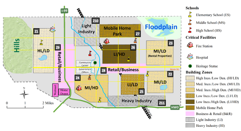 Figure 1. Plan view, showing major features of Centerville
Centerville is located approximately 200 miles from the New Madrid Seismic Zone, and thus is susceptible to low-probability moderate to major seismic hazards. It is also close to "tornado alley." Thus, both earthquake and tornado hazards are considered in assessing the resilience of the Centerville community. The study of Centerville, to date, has focused on the impact and prompt response of the community to a scenario earthquake with magnitude Mw = 7.7 and epicenter approximately 40 km SW of the center of the community. The impact of a scenario tornado will be considered in the next quarter.
Four physical systems in the Centerville built environment are considered in the testbed: buildings, transportation systems, electric power, and water/wastewater systems. These four systems were selected because: (1) The fragility modeling process for their components is most mature, and (2) They represent distinct civil infrastructure topologies, which will respond to demands from earthquake or tornado hazards in different ways: buildings are distributed infrastructure, while transportation, power and water/wastewater infrastructure are described by networks, albeit of different resolutions. The major road network is shown in Figure 2 below. The utility networks follow the road network right-of-ways, and thus are not shown. The fragilities needed to estimate damage to the Centerville physical infrastructure are being developed in other Center research tasks running in the current year. Meanwhile, fragilities from prior research, including the NSF-supported earthquake centers and HAZUS-MH, are being used to test the resilience assessment algorithms and to inform the linkages between performance of physical and socioeconomic systems. As an example, the total direct losses to the building inventory (structural losses, nonstructural losses and building contents) under the scenario earthquake above amount to approximately $856M, or approximately 8% of the assessed value of the building inventory. Similarly, the scenario earthquake leads to a 41% reduction in the average connectivity of the transportation network. Such numbers provide a portion of the input to the socioeconomic models.
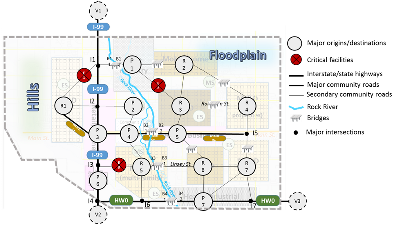 Figure 2. Centerville transportation network
The socioeconomic infrastructure systems in Centerville for each of the residential areas in Centerville are defined as a collection of Census Tracts and Block Groups by the US Census Bureau. Age, race, ethnicity, vacancy rates, and other demographic proportions in the Centerville testbed are based on Galveston, Texas, a town of similar size, using the American Community Survey data collected between 2006 and 2010. Income data for Centerville are based on Fort Collins Public Use Micro Data (PUMS), with modifications to account for the fact that the link between household income and number of workers does not exist at the Census Block Group level. While the socioeconomic model of Centerville represents a simplified version of neighborhood and worker structure, the model is sufficient to test the algorithms that relate physical infrastructure damage to socioeconomic impact, measured in terms of population dislocation (household migration), household income loss due to loss of employment, and loss of local government tax revenue.
The damage and losses to the physical infrastructure in the community determine the impact on its socioeconomic response. One of the ongoing Center tasks is concerned with identifying the metrics required to measure community resilience quantitatively and scientifically. This work is in an early stage of development by the sociology team, but is drawing heavily from the recently issued NIST Community Resilience Planning Guide for Buildings and Infrastructure Systems as well as other resources. The current Centerville testbed analysis is focusing on two metrics among the many that have been proposed in other studies - loss of jobs/income and outmigration - which are being related to physical infrastructure damage. Economic impact is being determined using Computable General Equilibrium (CGE) models, while social impact is being determined from semi-heuristic models based on prior natural disasters. Preliminary results indicate that without mitigation, the scenario earthquake results in a loss of approximately 1,500 jobs, or 6% of the workforce, and a decline in household income of $107M, or 7% of the household income in Centerville. Furthermore, approximately 10 - 15% of the population will have to relocate, absent any pre-disaster mitigation actions.
Part of the Centerville Testbed involves the development of decision algorithms to optimize community pre-disaster risk mitigation planning and post-disaster recovery. These decision algorithms integrate physical infrastructure engineering with social vulnerability and economic impacts. Two preliminary studies have been conducted, one dealing with bridge retrofit decisions prior to a scenario hazard, and one dealing with resource allocations to retrofit building types to specific code levels. A future newsletter will describe these decision models in more detail, along with how community recovery models are integrated into the Centerville Testbed.
< Go Back
Multi-Hazard Damage and Loss Assessment: Application for Earthquake and Tsunami to Seaside, Oregon
CoE Team: Dan Cox (OSU, lead), Andre Barbosa (OSU), Mikhail Gershfeld (Cal Poly), Jong Sung Lee (UIUC), Dorothy Reed (UW), Michael Scott (OSU), John van de Lindt (CSU), Navid Attary (CSU, Postdoc), Minjie Zhu (OSU, Postdoc), Shafiqual Alam (OSU, Grad), Hyoungsu Park (OSU, Grad), Stanley Wang (UW, Grad), Long Phan (NIST), Marc Levitan (NIST)
The overall objective of this work is to use Seaside, OR, as a test site to develop multi-hazard damage and loss assessment at parcel scale for a range of earthquake/tsunami scenarios originating from the Cascadia Subduction Zone (CSZ) hazard.
Seaside, OR, is a small coastal community with fewer than 6,000 residents, fewer than 10,000 buildings and simple topology in terms of networks for roads and other infrastructure. Because Seaside is an actual community, small, and sits in geographic isolation to neighboring communities, it allows a practical application for IN-CORE development. Additionally, coastal communities have a specific offshore bathymetry and coastal topography that needs to be included in a test-bed to allow accurate estimation of the inundation hazard, particularly the time varying flow depth, velocity, and momentum flux used as the basis for the fragility analysis. The tsunami inundation follows the earthquake ground shaking and ground failures, and the loss estimation for coastal communities needs to account for the effects of these cascading hazards. Thus, correlation of the damage obtained from individual hazards needs to be performed. Moreover, use of an actual city and its urban environment provides an opportunity to understand the level of detail (building description; economic values) available for model input, propagation of hazard and fragility uncertainties, and granularity to the resolution of tax-lot. Although the earthquake damage is fairly mature, there is still a need to develop methodologies for hurricane surge/wave, and the tsunami damage assessment in this task will help with future hurricane development. The multi-hazard analysis offers additional complexities for estimating main measures of community resilience.
The process and a preliminary damage and loss assessment have been completed for the buildings in Seaside to illustrate the steps required in Multi-Hazard Damage and Loss Assessment (Figure 1). In the following months, we will be completing the damage assessment for the bridges and other lifelines to estimate the damage and consequently estimating the direct losses for the whole community.
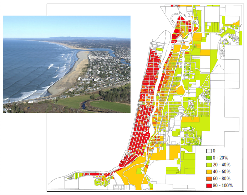
Figure 1: Estimates of the probability of complete building damage due to the combined effects of an earthquake and tsunami event originating from the Cascadia Subduction Zone resolved at the tax-lot level for the city of Seaside, OR (inset).
< Go Back
 News & Updates
 Photo Gallery
 Seminars